Canada
Pascal Oskam
This contribution is published in both Dutch and English. You will find the English version below.
| Nummer Koeman’s Atlantes Neerlandici, vol. II | 9130:2 |
| Titel kaart / Titel tekst | EXTREMA AMERICÆ VERSUS BOREAM / Nieu Vranckryck, met de bygelegen Landen |
Nieu Vranckryck of Nieuw Frankrijk was in de tijd van Blaeu een regio die vandaag de dag bekend staat als het oosten van Canada met bijgelegen eilanden. Het gebied strekte zich uit vanaf de kust van Noord-Amerika tot Newfoundland en Labrador.
Deze regio, als eerste “ontdekt”, bewoond en gekoloniseerd door Franse kolonisten, stond in de late zestiende eeuw en begin zeventiende eeuw vooral bekend om haar visrijke rivieren en zeeën. Zo schrijft Blaeu: ‘Het heele eylandt is doorsneden met verscheyde rivieren, en loopende wateren, die seer goede visschen voortbrengen, onder andere salmen, alen, en, boven alle, uytnemende goede voorens.’ Verder was de lucratieve walvisvangst een belangrijke factor voor de Franse aanwezigheid. Hierbij kreeg men hulp van de oorspronkelijke bevolking die in de beschrijvingen van Blaeu ‘wilden’ worden genoemd.
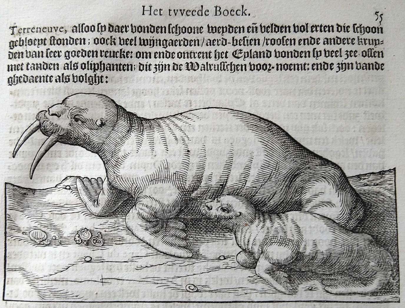 Johannes de Laet, Beschrijvinghe van West-Indien (Leiden: Elzevier,1630), p. 55
Hoewel het overgrote deel van de beschrijvingen over de natuurlijke historie van Nieuw Frankrijk gaat, heeft Blaeu ook aandacht voor de inwoners: de ‘wilden’. Maar waarom werd de bevolking op deze wijze bestempeld? Het antwoord ligt in de manier waarop de stammen afweken van de “beschaafde” Europese mens: ‘Sy bestieren sich ten meesten deel sonder wetten, sonder burgelijcke instellingen, op wijse der beesten.’ Ook het feit dat deze stammen niet geloofden in God vergrootte de afstand tussen de christelijke Europeanen en de oorspronkelijke bevolking. Volgens Blaeu zagen deze stammen er bovendien uit als barbaren die, zowel in uiterlijke kenmerken (half naakt) als in gewoonten, voor de kolonisten verre van beschaafd waren.
De kennis over het gebied Nieuw Frankrijk verkreeg Blaeu van twee andere kaarten die dit gebied besloegen: Nouvelle France (Samuel de Champlain) en Nova Francia (Johannes de Laet). Blaeu heeft deze kaarten gebruikt voor onder andere namen voor nederzettingen, rivieren en zeeën, als ook voor informatie omtrent de kustlijnen. Voor informatie over de oorspronkelijke volkeren en de natuurlijke historie leunde Blaeu vooral op twee Franse ontdekkingsreizigers genaamd Samuel de Champlain (ca. 1567-1635) en Jacques Cartier (1491-1557). Deze twee ontdekkingsreizigers worden in zijn beschrijvingen meermaals aangehaald. Dit is niet vreemd aangezien Blaeu beschikte over hun reisverslagen, die hij kort toelicht aan het eind van zijn beschrijving over dit interessante gebied bewoond door ‘wilden’.
Suggestie om verder te lezen:
Jonathan, L.H. (2022). “Translating empire, translating Cartier and Léry into English: text and context in comparative narratives of expansion and the new world,” Ilha Do Desterro, 75(2), pp. 45-64.
| Koeman’s Atlantes Neerlandici, vol. II | 9130:2 |
| Title map / Title text | EXTREMA AMERICÆ VERSUS BOREAM / Nieu Vranckryck, met de bygelegen Landen |
In Blaeu’s era, New France encompassed the area that is now eastern Canada and the maritime provinces, stretching from the American Northeast to Newfoundland and Labrador.
The region, which was ‘discovered’, and had been colonized, by the French, was mostly known in the late sixteenth and early seventeenth centuries for its rich fishing grounds. Blaeu writes: ‘Het heele eylandt is doorsneden met verscheyde rivieren, en loopende wateren, die seer goede visschen voortbrengen, onder andere salmen, alen, en, boven alle, uytnemende goede voorens’ [the entire island is teeming with rivers and streams, which produce excellent fish, such as salmon, eel, and above all, extremely good minnows]. Another important reason for the French presence was the lucrative whaling industry, in which the French welcomed the help of the local population.
Although the vast majority of his descriptions are about the natural history of New France, Blaeu also talks about the indigenous peoples, whom he describes as ‘wilden’ [savages]. Why would he call them that? The answer lies in the fact that Europeans considered any societies that differed significantly from their own as less civilized or primitive: ‘Sy bestieren sich ten meesten deel sonder wetten, sonder burgelijcke instellingen, op wijse der beesten’ [they mostly live without laws, without civil institutions, much like beasts]. The fact that these tribes did not believe in God also contributed to the distance between the Christian colonizers and the indigenous peoples. What is more, Blaeu claims that these tribes looked like barbarians and that they were far from civilized, both in their physical appearance and clothing, or lack thereof, and in their customs, and lifestyle.
Blaeu gained his knowledge about New France from two other maps of the region: Nouvelle France (Samuel de Champlain) and Nova Francia (Johannes de Laet). He used both these maps as reference works for the names of settlements, rivers, and oceans, and for information about coast lines. For details on the region’s indigenous peoples and its natural history, Blaeu mainly drew upon the knowledge of two French explorers, i.e. Samuel de Champlain (ca. 1567-1635) and Jacques Cartier (1491-1557). The fact that he repeatedly references these two authors in his descriptions should come as no surprise as Blaeu had access to their travel journals, which he touches upon towards the end of his description of this interesting region inhabited by ‘wilden’ [savages].
Further reading:
Jonathan, L.H. (2022). “Translating empire, translating Cartier and Léry into English: text and context in comparative narratives of expansion and the new world,” Ilha Do Desterro, 75(2), pp. 45-64.
