Pernambuco and Paraiba
Noah Wubs
This contribution is published in both Dutch and English. You will find the English version below.
| Nummer Koeman’s Atlantes Neerlandici, vol. II | 9850/4:2D |
| Titel kaart / Titel tekst | PRÆFECTURÆ DE PARAIBA ET RIO GRANDE / ‘t Gouvernement van Paraiba |
De gouvernementen Pernambuco en Paraiba liggen in de oostelijke punt van het Zuid-Amerikaanse continent in het huidige Brazilië. In de regiobeschrijvingen van Blaeu wordt het gebied uitvoerig beschreven. Zo worden er steden, dorpen, rivieren en grondstoffen genoemd. Een belangrijk product uit het gebied was suiker. Dit komt ook tot uiting in de tekst en prenten bij de kaarten. Verschillende suikerrietplantages en raffinaderijen worden genoemd, in een van de prenten in de atlas wordt zo’n raffinaderij getoond. Suiker werd vrijwel exclusief voor de Europese markt verbouwd en was commercieel zeer lucratief. In de late zestiende en eerste helft van de zeventiende eeuw was beheersing van (delen van) Pernambuco en Paraiba dan ook aanleiding tot Europese conflicten.
Zo worden door Blaeu verschillende machtswisselingen genoemd in de tekst. De Fransen waren de eersten die actief waren in dit gebied, maar werden door de Portugezen met behulp van de oorspronkelijke bevolking in 1584 uit dit gebied verdreven. In de jaren dertig van de zeventiende eeuw begonnen de Nederlanders met hun verovering van de suikerproducerende gebieden. De Nederlandse expansie kwam in een stroomversnelling door de verovering van het Portugese steunpunt Olinda in 1632. Maar de aanwezigheid bleek van relatief korte duur. Door hevige tegenstand van Portugese kolonisten en oorspronkelijke bewoners moesten de Nederlanders in 1654 definitief hun aanwezigheid in Brazilië opgeven. De herovering door de Portugezen, ook al verscheen de Grooten Atlas ruim een decennium later, blijft in de tekst geheel onvermeld. Ook op de bijbehorende kaart is de Nederlandse aanwezigheid nog volop zichtbaar.
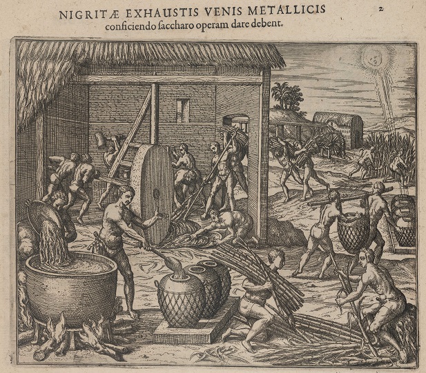
Jacques Le Moyne, Brevis narratio eorum quae in Florida Americae Provincia Gallis acciderunt (Frankfurt am Main: Johann Wechel, 1591), part 5, fol. 2: the production of sugar
Aan de oorspronkelijke bewoners die leefden in het gebied worden slechts enkele passages gewijd. De Amerindianen worden door Blaeu steevast “wilden” genoemd. Helemaal niet genoemd worden de joodse kolonisten. Uit historisch onderzoek weten we dat zij een grote ondersteunende rol hebben gespeeld bij de Nederlandse expansie in de Braziliaanse gouvernementen, maar ze blijven door Blaeu onvermeld. Dezelfde marginalisering ondergaan slaafgemaakte Afrikanen, die werkten op de suikerrietplantages en in de molens. Aandacht is er voor de Europese aanwezigheid, zij het Frans, Portugees of Nederlands, in het gebied en (met name) welke lucratieve producten er vandaan kwamen.
Suggestie om verder te lezen:
Lint, J. de (2020). Pernambuco, the Dutch in Brazil 1624-1654. Zwaag: Pumbo.
| Koeman’s Atlantes Neerlandici, vol. II | 9850/4:2D |
| Title map / Title text | PRÆFECTURÆ DE PARAIBA ET RIO GRANDE / ‘t Gouvernement van Paraiba |
The governorships of Pernambuco and Paraíba were located in the South American northeast, in what is now Brazil. Blaeu writes extensively about the region in his texts, naming its cities, towns and villages, rivers, and natural resources. This region was known for its sugar production. Sugar was a valuable commodity at the time and this is reflected in the descriptions and illustrations accompanying the maps. Blaeu mentions different sugar plantations and refineries, and one of the illustrations in the atlas is of a sugar refinery. Sugar was produced virtually exclusively for the European market and the sugar business was highly lucrative. As a result, in the late sixteenth and early seventeenth centuries, European powers fought for control of parts of Pernambuco and Paraíba.
Blaeu mentions a number of power shifts in his text. The French were the first to settle in this region, but they were driven out by the Portuguese in 1584 with the aid of their indigenous allies. In the 1630s, the Dutch started to rise to power in the sugarcane industry by conquering the sugar-producing areas. The Dutch expansion drive accelerated with their capture of Portuguese-controlled Olinda in 1632 in an attempt to control the sugarcane trade in Brazil. But their presence would be short-lived. Fierce resistance by the Portuguese and the indigenous population forced the Dutch to leave Brazil permanently in 1654. Blaeu does not make any mention in his Atlas Maior of the recapture by the Portuguese, even though that happened more than a decade before the atlas was published. Blaeu’s map of Brazil still shows the Dutch presence as well.
There are only a few passages about the indigenous population in the region, who are consistently referred to as ‘wilden’ [savages]. The Jewish settlers in the region go entirely unmentioned. Historical studies show that they played a prominent role in supporting the Dutch expansion in the Brazilian governorships, but Blaeu leaves them out entirely. Enslaved Africans, who worked on the sugar plantations and in the sugar mills, suffered the same marginalization. Blaeu focused only on the European presence in the region, whether French, Portuguese, or Dutch, and on the mainly profitable products that were produced there.
Further reading:
Lint, J. de (2020). Pernambuco, the Dutch in Brazil 1624-1654. Zwaag: Pumbo.
